National Geographic Online has atlas puzzles - very, very cool! Addictive but in a good way. Go jigsaw your little heart out! I am not to blame for lost hours of productivity.
Wednesday, April 30, 2008
Puzzling
Monday, April 28, 2008
Look Now Look All Around
Clearly I was going to go see something that City Paper described as “an elusive little show” about mapping. And I did. “Look Now Look All Around” is at the Maryland State Arts Council offices on
Friday, April 25, 2008
Where in the World is…?
A Friend Of A Friend sent me this photo. (My reputation as Her Majesty is spreading; I’m not sure if I’m flattered or a little bit creeped out.) My FOAF’s family has a wall-mounted map in their house where they plot every place they’ve been -- one color pin for trips where FOAF goes alone, another color for where Mrs. FOAF has been, and a third color for where they have been with their little FOAF kid-lings. Cool idea… and lucky kids! Look at all those pins in the Caribbean and
Thursday, April 24, 2008
Down to the Wire
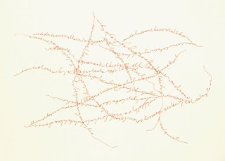
You know by now that I’m not the craft type. But I’ll make an exception – when it’s a cool map. Like these, made by “The Wire Lady” Elizabeth Berrian. Suitable for hanging.
Wednesday, April 23, 2008
Never Lost
The guy who helps me at my neighborhood Kinko’s has a tattoo of
Tuesday, April 22, 2008
Day and Night
If you’re reading this in, say,
Monday, April 14, 2008
Raise Your Hand
So here’s a neat thing… the Hand Drawn Map Association! www.handmaps.org (Who knew?!) What a way cool idea – a repository of, you guessed it, hand-drawn maps. I love it. I’m in. (see above: showing my mother how to get to Holy Frijoles in Hampden)
Sunday, April 13, 2008
The Karmphleuterstam Provinces?
Or a map depicting the political divisions of Traignothingham following the Mreptipol uprising? The topography of Ghreishenstat? Geothermographical waves in Qarestinen following the 2001 hurricane?
Nope. Just the bark of a tree at Pompeii. (I found this photo I took many years ago while I while organizing my pics last night.)
Friday, April 11, 2008
Let’s Map Some Trees
Hey tree huggers: this Saturday is the opening event for the Urban Forest Project here in B’More. There are all these really cool designy banners being put up all over the city that celebrate trees and a driving tour (map above) where you can check them out. Here are the detes. I may check out the party Saturday at “the Beach” at
Wednesday, April 9, 2008
Maps in Clay! (Who Knew?)
I’ve never been one for molding things out of clay. After all, I AM her majesty. (Plus, I once took a pottery class and let’s just say things came out somewhat bumpy and lumpy… which made me grumpy.) But I am definitely pro-looking-at-people’s-work-who-are- sculpturally-inclined. And combine that with something about maps, and I’m there!
Tuesday, April 8, 2008
I See London
I’ve only been to
The map is also a cool way to check out lots of other way cool stuff that I don’t really know what it is but it’s still way cool. You can see the real routes of the
Monday, April 7, 2008
See the Walters Exhibit from Your Barcalounger!
Just in case you’re not in
Friday, April 4, 2008
Ah-Choo(se a Map)
Did you miss me? Her Majesty has been sneezing up a royal storm and coughing up ye annual royal phlegm the past few days. I’ve been a little under the weather and off the map. Not my favorite time of year. … except it gave me an excuse to do this:
The American Lung Association’s allergy map.
Tuesday, April 1, 2008
Happy AF Day
And I don’t mean Abercrombie & Fitch! (I’m not that kind of princess).
That reminded me of the “New Yorkistan” map from the New Yorker.
Here’s an interesting article about this genre of map.


 My StumbleUpon Page